Cape Cod Bay
Monitoring
Program

   C I T I Z E N   S C I E N C E

Welcome to the Future of Ecosystem Management

An initiative of the Provincetown Center for Coastal Studies


Threats to the Bay
 
Monitoring Stations Map
 
Citizen Scientists
 
Collaborators & Links
 
Input Data
 

  Monitoring Stations:

  - Provincetown Harbor
  - Pamet River
  - Herring River

  - Pilgrim Lake/Pilgrim Lake

    East

  - North Sunken Meadow

  - Boat Meadow

  - Cole Road Beach
  - Little Namskaket
  - Namskaket

  - Upper Namskaket
  - Paines Creek
  - Grays Beach
  - Barnstable Harbor
  - Scorton Harbor
  - Upper Scorton Creek
  - Old Harbor (Sandwich)
  - Upper Old Harbor Creek
  - Ellisville Harbor
  - Plymouth Harbor
  - Jones River

  - Quivet Marsh

  - Duck Creek (Wellfleet)

  - Sesuit Harbor

  - Millway Beach

 - References


STATION:
PLYMOUTH HARBOR

last updated 04.01.2014


Geographic Location:
  42 05.39  |  70 56.22

Current Volunteer Monitor: SHEILA SHERIDAN

Site Description:

Under the National Pollutant Discharge Elimination System (NPDES), The Town of Plymouth Department of Public Works is authorized to discharge from Plymouth Wastewater Treatment Plant into Plymouth Harbor. Plymouth Harbor is also designated an impaired waterway (2006 Massachusetts 303(d) List of Impaired Waterbodies), due primarily to bacterial contamination and so is closed to all shellfishing. For these reasons, monitoring the water quality at this site is particularly important. For more information on other organizations active in water quality monitoring in and around Plymouth, visit www.plymouthwaterquality.org.

Images:

Plymouth HarborPlymouth Harbor


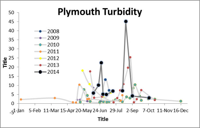
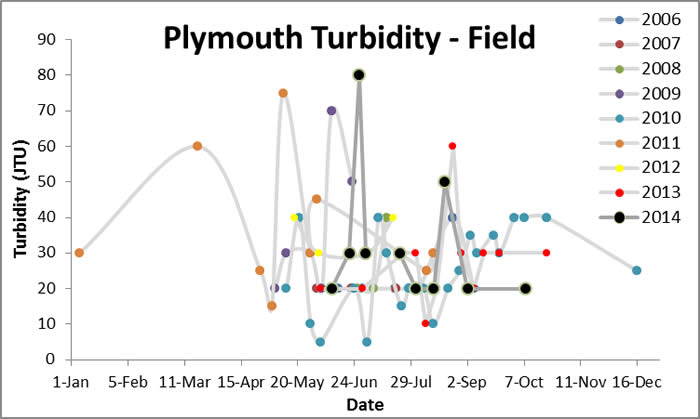
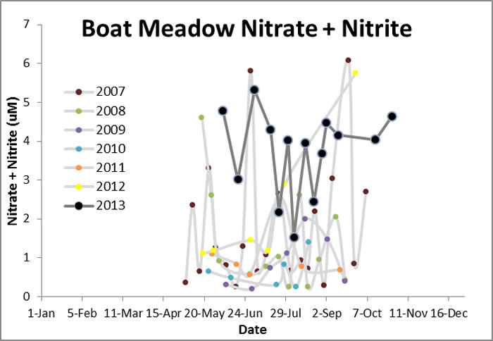
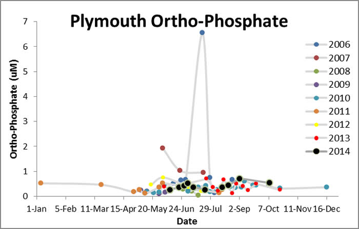
Water Quality Data: Plymouth Harbor 2006-2013: Plymouth


Water Quality:


CONTACT

CITIZEN SCIENTIST HOMEPAGE