Geology
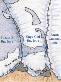
Figure 1
Around 25,000 years before present (ybp), the sprawling Laurentide ice sheet poured out of Canada into New England. Fueled by the Wisconsinan Ice Age and the surrounding seas, much of the earth’s water was converted into ice, and that ice piled high and began to move. It fanned out in all directions, plowing and grinding the earth ahead of it. At its climax, lobes of the Laurentide pushed as far south as present day Long Island, Block Island, Martha’s Vineyard and Nantucket Island.
By about 21,000 ybp, the Laurentide ice sheet had reached its southern limit, with three lobes extending into our area (figure 1: the darker, outlined area represents the region as it looks today with Boston, Cape Cod, Martha’s Vineyard and Stellwagen Bank). With so much of the ocean’s water locked up in ice, the sea level was about 300 feet lower than it is today.
As the ice pushed south, piles of sand and gravel called moraines were driven ahead of it (see figure 2). Earth also poured out of the glaciers to create outwash plains.
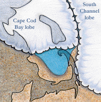
Figure 2
These deposits stretched out into the southern shore. Large moraines left at the heads of the Buzzards Bay and Cape Cod Bay lobes created the highest points remaining on Martha’s Vineyard and Nantucket.
As the Laurentide ice sheet continued to retreat in general, each lobe lost ground at its own pace. The Cape Cod Bay lobe, in particular, was shrinking more rapidly than the others. The land it left behind had been depressed by the sheer weight of ice.
This depression filled with meltwater and sediments, forming a huge lake populated with numerous deltas. The lake was bounded by ice to the north and east and by older deposits (dry land) to the south and west. Rivers of melted water poured from the western edge of the South Channel lobe creating outwash plains and deltas. These formed the basis of
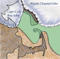
Figure 3
Outer Cape Cod. At this point, the space that would become Stellwagen Bank was being scoured by a sheet of ice 2,000 feet thick.
By about 18,000 ybp, ice was melting rapidly (and would do so until its disappearance, 5,000 years ago). This loss in glaciers created a gain in sea level. By now the South Channel lobe was pouring deltas of sand and gravel from its western flank into the newly flooded bay. These same deposits still move with the tides on Stellwagen today.
At about 12,000 ybp, land once held down by the heavy load of glaciers rebounded (see figure 3). Most of Stellwagen Bank was left high and dry. Like its neighbor, the Outer Cape, marshes colonized its fringes; forests of spruce and poplar supported mammoths and mastadons.
Another thousand years and native people experienced the end of crustal rebounding and the continued flooding by sea level rise. And by 10,000 ybp, tides began to cross the Bank. Waves and wind would continue the work of the Laurentide ice sheet, eroding and redepositing glacial deposits into the shape of present day Stellwagen Bank and Cape Cod.