Pleasant Bay Tidal Data
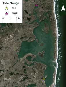
Pleasant Bay is a large and dynamic estuary in Cape Cod bordered by the towns of Brewster, Chatham, Harwich and Orleans. CH = Chatham Fish Pier MHP = Meeting House Pond
Pleasant Bay is undergoing a long-term cycle with inlets to the open ocean migrating, closing, and breaking open over decades. These changes in the shape of the estuary influence and are influenced by the tidal cycle, and impact water quality, marine resources and navigation.
The Center for Coastal Studies has partnered with scientists from the Cape Cod National Seashore and the Pleasant Bay Alliance to record tidal data in Pleasant Bay.
Comparing data from our tidal gauge in Meeting House Pond at the northernmost part of Pleasant Bay with tidal data from National Oceanic and Atmospheric Administration (NOAA) tide gauges at the Chatham Fish Pier and Boston Harbor allows us to observe long-term tidal trends. These patterns tell us how the Pleasant Bay tidal prism (the volume of water entering and exiting the estuary) is affected by regional sea level changes and local impacts of the changing major inlets.
Click on the links below to view Meeting House Pond tidal data by year or download all monthly tidal data here.
This project is funded in part under an agreement with the Cape Cod National Seashore, National Park Service. The Pleasant Bay Alliance has been sponsoring the collection and interpretation of the data in partnership with the Center since 2007.
Our Work
Humpback Whale Research
Right Whale Research
Marine Animal Entanglement Response
Marine Geology Department
Water Quality Monitoring Program
Marine Fisheries Research
Seal Research
Shark Research
Marine Education
Interdisciplinary
Marine Debris and Plastics Program
Marine Policy Initiative
Cape Cod Climate Change Collaborative
Publications
