Outer Cape Cod
 Cape Cod’s ocean coastline presents a naturally dramatic and strikingly beautiful moving picture formed by a continual interplay of earth, sea, atmosphere, and life. These interactions produce the landforms, and the landforms alter the interactions in an endlessly compelling dynamic. The resulting landforms-sea cliffs, dunes, spits, barrier beaches, salt marshes and estuaries-provide habitats for an amazing array of coastal plants and animals. The habitats, their inhabitants, and the interacting environmental factors controlling them constitute the Cape’s ecosystems. The Center’s coastal geology program focuses on the landforms that provide the physical framework for those ecosystems.
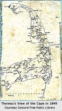
The outer coast of Cape Cod, extending from Long Point in Provincetown for over 60 miles to Monomoy Point in Chatham and named the “Great Beach” by Henry David Thoreau when he walked the greater part of its length in 1849 and again several years later constitutes a single system of sediment transported by wave and tidal action. Although it appears little changed since the Pilgrims’ landfall 350 years ago, it is in fact the most dynamically changed of all of Cape 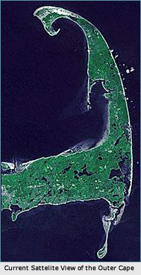 Cod’s many shores. Its notoriety for quickly shifting shoals in response to vicious Northeast storms comes mainly from the scores of 17th, 18th and 19th century ship wrecks that litter its bottom, and which earned it the nickname “Graveyard of the Atlantic;” home to perhaps the most notorious of all Cape Cod shipwrecks, the pirate ship “Whydah,” which ran aground in 1717 during just such a northeast gale.
Largely for this reason, the outer Cape Cod coast, or “backside,” as it is known locally, ranks as one of the world’s most thoroughly studied by geologists and physical geographers. The basic sedimentation system is straightforward: the central coast consists of sea cliffs-made up of sand and gravel deposited by retreating glaciers-which, when eroded by storm waves, dump tons of sand to construct the beaches that front them as well as the spits and barrier beaches that extend to their north and south.
This coastal system produces an incredibly diverse set of landforms and habitats that contribute to its enormous popularity with all forms of beachgoers: surf-casters, sunbathers, surfers, birdwatchers and hikers. This leads to complex management issues further complicated by the many different political jurisdictions in which they lie. These jurisdictions consist of five Barnstable County towns, each charged with enforcing State environmental regulations as well as their own, and two federal agencies — the Cape Cod National Seashore and the Monomoy Wildlife Refuge — with overlapping boundaries and potentially conflicting priorities.


Our Work
Humpback Whale Research
Right Whale Research
Marine Animal Entanglement Response
Marine Geology Department
Water Quality Monitoring Program
Marine Fisheries Research
Seal Research
Shark Research
Marine Education
Interdisciplinary
Marine Debris and Plastics Program
Marine Policy Initiative
Cape Cod Climate Change Collaborative
Publications